Musandam Governorate
Musandam Governorate
مُحَافَظَة مُسَنْدَم | |
|---|---|
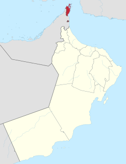
 Musandam Governorate of Oman. The exclave of Madha is indicated in red below the Musandam Peninsula. | |
| Coordinates: 25°55′N 56°17′E / 25.917°N 56.283°E | |
| Country | |
| Capital | Khasab |
| Government | |
| • Sultan | Haitham bin Tariq Al Said |
| • Governor | Sayyid Ibrahim bin Said al Busaidy |
| Area | |
• Total | 1,800 km2 (700 sq mi) |
| Population (2020 census) | |
• Total | 49,062 |
| • Density | 27/km2 (71/sq mi) |
The Musandam Governorate (Arabic: مُحَافَظَة مُسَنْدَم, romanized: Muḥāfaẓat Musandam) is a governorate of Oman. With the exception of the exclave of Madha,[1] it is located on the Musandam Peninsula, which juts into the Strait of Hormuz, the narrow entry into the Persian Gulf, from the Arabian Peninsula. The governorate is also an exclave, separated from the rest of Oman by the United Arab Emirates. Its location gives Oman partial control, shared with Iran, of the strategic strait. In the northern section of Musandam, around Kumzar, the language is Kumzari, which is a southwestern Iranian language closely related to Larestani and Luri. The Musandam Peninsula has an area of 1,800 km2 (690 sq mi) and, at the 2020 census, a population of 49,062.

Access to the peninsula was formerly difficult, with the only options being limited flights or a ten-hour drive through four immigration posts. The Shinas fast ferry service between Muscat and Musandam was launched in August 2008 to alleviate this problem and make the region more accessible.[2] The governorate is accessible by land only from the United Arab Emirates. Mainland Musandam can be accessed by Ras al-Khaimah near Al-Jeer via Route 2, and an exclave of Sharjah, Dibba Al-Hisn. Oman Air provides an air link between the capital of the country, Muscat, and the main administrative town of the governorate, Khasab.
History
[edit]Isolated from surrounding powers by mountainous terrain and a rocky coast,[3] the Musandam peninsula was historically self-ruled by local tribes including the Shihuh[3] and Habus.[4] By the early 20th century, Musandam was claimed by the Sultan of Oman who stationed a representative in Khasab.[5][3] The Sultan did not exert effective control over the area, neither collecting tax[5] nor establishing a military presence,[6] and the peninsula continued to be ruled by local tribes. In 1970-71, following the British backed 1970 Omani coup d'état, British and Trucial Oman Scout[7] forces invaded Musandam ending local rule[8] and establishing a permanent Omani military force.[6]
Provinces
[edit]Musandam Governorate consists of four provinces:[1]
- Khasab, the regional centre of the Governorate
- Bukha
- Dibba Al-Bay'ah
- Madha, itself an exclave, located half-way between the rest of Musandam and Oman proper
The area has great strategic importance owing to its proximity to the Strait of Hormuz. The administrative head of Governorate is governor and minister of state. The current governor is Sayyid Ibrahim bin Said al Busaidy (الـسَّـیِّـد ابراهيم بن سيد بن ابراهيم الْـبُـوسَـعِـيـدي).[9]
Geography
[edit]
The rugged coastline resembles the glacier-carved coasts of polar regions, but in this case, the coast was shaped by the movement of Earth's crust. The Arabian Plate is slowly pushing under the Eurasian Plate, creating the earthquake-prone mountains of Iran. On the leading edge of the Arabian Plate, the Musandam Peninsula is sinking. The higher elevation mountains remain above the water, but the sea has rushed in to fill the valleys with fingers of water.[10]
Demographics
[edit]| Census year | Pop. | ±% p.a. | ||
|---|---|---|---|---|
| 1993 | 28,727 | — | ||
| 2003 | 28,378 | −0.12% | ||
| 2010 | 31,425 | +1.47% | ||
| 2020 | 49,062 | +4.56% | ||
| ||||
| Source: Citypopulation[11] | ||||
See also
[edit]References
[edit]- ^ a b Lancaster, Fidelity; Lancaster, William (2011). Honour is in Contentment: Life Before Oil in Ras Al-Khaimah (UAE) and Some Neighbouring Regions. Berlin, New York: Walter de Gruyter. pp. 3–265. ISBN 978-3-1102-2339-2.
- ^ "Oman launches high-speed ferry". Gulf News. 26 July 2008.
- ^ a b c Thomas, Bertram (1929). "The Musandam peninsula and its people the Shihuh". Journal of the Royal Central Asian Society. 16 (1): 71–72. doi:10.1080/03068372908725040. ISSN 0035-8789.
- ^ Anthony, John Duke (1974). "Political dynamics in the Sultanate of Oman" (PDF). apps.dtic.mil. p. 10. Retrieved 31 October 2024.
- ^ a b Yates, Athol; Hughes, Geraint (3 October 2022). "Operation Intradon in the Musandam,1970-1971: what this counterinsurgency operation says about British military operations in the Arabian Gulf". Small Wars & Insurgencies. 33 (7): 1236–1258. doi:10.1080/09592318.2022.2066305. ISSN 0959-2318.
- ^ Bradshaw, Tancred (1 November 2020). "Security forces and the end of empire in the Trucial States, 1960–1971". Middle Eastern Studies. 56 (6): 1019–1033. doi:10.1080/00263206.2020.1805318. ISSN 0026-3206.
- ^ "Stealing a nation – the secret SAS mission to capture the Middle East's oil artery • Declassified UK". Declassified UK. 22 October 2021. Retrieved 24 October 2021.
- ^ "Prince William begins Oman visit in Musandam". Oman Observer. Retrieved 23 January 2020.
- ^ "Musandam Peninsula, Oman". NASA Earth Observatory. 15 April 2009. Retrieved 23 January 2020.
- ^ "Oman: Governorates". www.citypopulation.de.
External links
[edit]- Map showing the territory
- Musandam Peninsula, Oman at the NASA Earth Observatory
